Total Pageviews

Showing posts with label aboriginal. Show all posts

Friday, March 27, 2015

A VISIT TO SOME MYSTERIOUS LITTLE ISLANDS

One thing I love to do when I am visiting friends in Athens is to go on the Senior's Bus Tour.  These are special bus tours designed for seniors (although sometimes younger people are aboard too).  My friend Carol told me about them and last year we went on one to Euboea, crossing the island to the east coast to view towns and villages I'd never seen before We ended up on a lovely beach where we spent several hours.
These tours are like 'magical mystery tours' and usually go to destinations even the Greeks don't visit.  This year it was a trip to some mysterious islands off the north-east coast. 

The price for these day tours is reasonable (usually about 25  Euro). We boarded the bus early in the morning and headed up the coast to a town named Kamena Vourla noted for it's resort hotels. From there we got on a boat and head out into the Malian Gulf that separates Euboea from the mainland. 


It was an overcast day which made the trip seem even more mysterious.  We were headed toward Monolia Island which is apparently steeped in legend. As the story goes, Hercules won a bride in a battle. Her name was Deianira. After a time, she learned he took another woman as his favorite. Deianira send a servant, Lichas, to take a 'gift' to Hercules. It was a cloak. And when Hercules put it on his skin started to burn and he knew it was a poisoned cloak so he threw the servant into the sea. Licha broke up into pieces and Poseidon the sea-god turned the pieces into stones and created the Lichades Islands.
Of course, more logically, these islands were formed by a prehistoric volcanic eruptions and further reshaped from an upheaval of an earthquake in 426 BC. 
 Roman Ruins
 Volcanic remains forming islets

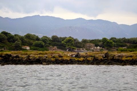
Remains of settlements.
One of the islets has some Roman ruins, another a lighthouse. There was a settlement on Monolia, and along the shore  you can see abandoned stone houses. There may be still people living there as I saw a woman on the pathway leading into the trees.  According to what I've read there are bars and pensions on the island but we didn't see them from our small boat. 


We circled Monolia and the boat anchored at Lixadonisi island where there is a small beach strewn with beach chairs, deserted on this chilly day. Usually the beach is crowded and popular with kayakers.  It was our intention to have a picnic here but the weather proved to be too inclement.  A few folks braved the chill and went swimming while the rest of us shivered on the shore.
 Lixadonisis Island 


To compensate, after failing to picnic or even sight the monachus monachus sea turtles that are usually present in the area, we boarded our boat again and headed back to Kamena Vourla.  There we were treated to a buffet lunch at the posh Galini Wellness Resort  http://mapcarta.com/12868100 Kamena Vourla
Galini Wellness Resort, Kamena Vourla 
Kamena Vourla is famous for the hot springs and boasts several resort hotels. Nearby, up the hill, is the monastery of Iera Moni Metamorfoseos tou Sotiros built around the 11th century. We didn't visit the monastary but were treated to a stop at the monument and museum to the Battle of Thermopylae located nearby.


NEXT: The monument to the Battle of Themopylae.


Thursday, September 13, 2012

MY CARIBOO ROAD TRIP: Part One

NORTH TO THE KLONDIKE GOLD FIELDS:  HOPE AND BEYOND

For years I've been wanting to visit the old gold rush town of Barkerville in British Columbia's Cariboo district and finally this year I managed to accomplish this.  It's a long trip by bus, 10 hours from Vancouver, but the journey was well worth it, through some of the west coast's most spectacular scenery.
The first brief stop along the way was the town of Hope. (The sign itself captured my attention!) Hope is the entryway to the Fraser Canyon where the mighty Fraser and Coquihalla rivers join. The town is nestled in the mountain pass of the Cascade and Coast Mountains.

Heading north, we soon pass the famous "Hells Gate", located immediately downstream of Boston Bar in the Fraser Canyon. Here the towering rock faces of the Fraser River plunge toward each other creating rapids.  From here you can go on river rafting excursion through this narrow passage of roiling water.


This has also been a popular fishing ground for the local aboriginal communities and in the past, European settlers also congregated there to fish for salmon.  It was on this route that the gold rush miners traversed up the river to the Cariboo gold fields.

This is also the canyon area where the first explorers came paddling down the river or portaging to the Coast. The scenery is spectacular, still as wild as it was then when later men trudged north in search of gold.

North, toward the village of Cache Creek, there were the remains of forest fires that had ravaged the countryside in recent years.

Cache Creek is located at the junction of the Trans Canada Highway and Highway 97 on the Thompson Plateau, junction of the Cariboo and Thompson Valleys. There are rolling grasslands and hills covered in sagebrush and cactus with a backdrop of beautiful mountains.


Cache Creek was the halfway point for prospectors en route to the Cariboo Gold Fields. Here (above) you'll see a way-marker pointing in the directions of the many places these hopeful miners came from. Many were from California, others from England, Scotland, Ireland and other European countries.  Today travelers like myself who are following the historical gold rush trail still stop off at Cache Creek.

All along the route are pristine lakes.  The little town of Lac La Hache is renowned for excellent fishing. The lake is a popular for swimming, boating, parasailing, water skiing and camping. Even in the winter there are activities such as ice fishing, cross country skiing and skating.  I was most impressed by Lac La Hache. For many years I knew the name but this was the first time I'd visited there.

 
Next stop is the rustic village of 100 Mile (also known as "Hundred Mile House") located on a plateau where there are numerous lakes.  The area is excellent for swimming, fishing, bird watching and horse-back riding. For thousands of years the Chilcotin First Nations lived, hunted and traded here and still claim the region as their traditional territory. In the mid 1800's miners flocked to the area folling the news of gold in the Cariboo. A wagon road was built to manage the traffic that came up from Lilloet on the Fraser River north to Barkerville. At the time, this was known as Bridge Creek House and was renamed 100 Mile House because it was 100 miles from Lilloet (Mile 0). Between 1862 and 1870 there were more than 100,000 travelers through this region. Eventually a freight and stagecoach line carried people and provision to the gold fields, cattle were imported and a thriving ranching culture developed.  By the 1900's logging and forestry became the dominant economic source.  Today tourism, logging and ranching are the leading industries in the South Cariboo.

After Lac la Hache, passing through 100 Mile, there is another spectacular lake known as Dragon Lake.  At the north end of this lake is Williams Lake, a small town in the central Cariboo. They are famous for the Williams Lake Stampeded. The town is named in honour of Secwepemc chief William who was instrumental in counselling the Shuswap band from joining the Chilcotin in their uprising against the new settlers back in the 1860's during the Cariboo Gold Rush.

This entire area is so rich with history, that for a history-buff like me it was a treasure trove of stories, added to the magnificent scenery.  It was easy to imagine being one of those early settlers, the men trudging north to the gold fields, or the brave explorers who came down the river to the west coast.

The Cariboo Gold Rush attracted a rush of American prospectors to the Fraser Canyon in 1858 Many stayed on as permanent settlers. Others began to explore the rest of the province searching for new finds. It was after Billy Barker, a miner from England, struck pay-dirt north in Barkerville, that floods of men arrived from other parts of the world seeking their fortune in the gold fields around Quesnel.  The area became known as "the Cariboo", NOT "Caribou", which is an Algonquin word "xalibu" meaning "a pawer or scracher'. In BC it is regarded as a corruption of the French word "Cariboeu or Cerboeuf" meaning "reindeer" as it is a favorite haunt of that species.

After ten enjoyable hours on the Greyhound bus, by 6.30 pm that evening I arrived at the town of Quesnel where the next phase of my Cariboo adventure began.

NEXT: Part II.  Quesnel and beyond.


Monday, February 09, 2009

THE 2010 ABORIGINAL PAVILION CEREMONIES

THE 2010 ABORIGINAL PAVILION UNVEILED

Last week I attended the official unveiling of the 2010 Aboriginal Pavilion to be built for the 2010 Winter Olympics. Aboriginal and other leaders from across Canada joined the Four Host First Nations and members of VANOC to unveil the pavilion which will celebrate the rich cultures and diversity of Aboriginal Peoples in Canada -- First Nations, Inuit and Metis.

.


The c,000 square foot pavilion will be located on the plaza of the Queen Elizabeth Theatre in downtown Vancouver, right in the heart of Olympic activity. A 65 ft. high spherical air-supported dome will be built using the latest technology to showcase the best of Aboriginal art, business, culture and sport from every region in Canada. The site will include a long-house containing a trading post for Aboriginal arts and crafts. The adjacent restaurants will be used for hospitality events. The event has been described as “the biggest potlach ever.” This sentiment was echoed by Vancouver’s Mayor Gregor Robertson who said he saw the pavilion as “the real heart and centre and soul of the 2010 Games.”

The ceremonies included a ceremony to introduce the official Aboriginal witnesses, speeches by tribal chiefs, including the National Chief, Phil Fontaine, and other dignitaries such as Gordon Campbell, the Premier of B.C. and Gregor Robertson the mayor of Vancouver, and various elders.

There was entertainment provided by a Metis jigger, an Inuit drummer and a First Nations hoop dancer.

Every member of the audience who witnessed the ceremonies were asked in First Nations tradition to carry it home and share it with their friends and family. The four Host First Nations -- the Lil-wat, Musqueam, Squamish and Tsleil-Waututh - will welcome the world to their shared ancestral territories. It is the tradition of the Coast Salish people to welcome visitors by saying “I hold my hands up to you” and the feathers in the design of the Four Host First Nation’s logo represents this.

Because the Games will be staged on the traditional territorial lands of the Four Host First Nations people, the host nations will play an integral role in the Games. Special “theme” days will celebrate Aboriginal groups from all regions of Canada. There will be live events including Inuit throat singing, Metis jigging, First Nations hoop dancing as well as other contemporary Aboriginal performances. Visitors at the site will also experience a state of the art multi-media show projected on screens both inside and out.

The pavilion will open in February 2010 and run throughout the Winter Olympic Games.
For more information visit www.fourhostfirstnations.com and download the fact sheet


Add to Technorati Favorites
Posted by Picasa